The Bridge at the End of the Street
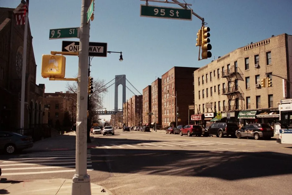
Walk south on almost any avenue in Bay Ridge and a gray tower appears at the end of it. Stand at the right corner on 95th Street and the whole thing lines up between the rowhouses like scenery someone wheeled in.
Visitors stop and take a photograph. People who live here have mostly stopped noticing, which is a shame: the structure at the bottom of the hill is one of the more remarkable objects in New York City. Here is the version worth knowing, plus where to stand.
What It Actually Is
The Verrazzano-Narrows Bridge is a double-decked suspension bridge across the Narrows, the tidal strait between Brooklyn and Staten Island that forms the gateway to New York Harbor. The Brooklyn end lands at Fort Hamilton, on the southern edge of Bay Ridge; the Staten Island end lands at Fort Wadsworth. Both forts were there first, by more than a century.
It opened to traffic on November 21, 1964, with the lower level following in 1969. The designer was Othmar Ammann, the engineer behind the George Washington, Bayonne and Throgs Neck bridges, and this was the last of his great New York crossings.
The numbers that are actually interesting
- 4,260 feet between the towers. Roughly four fifths of a mile of unsupported span.
- The longest in the world when it opened, and for seventeen years after, until the Humber Bridge in England passed it in 1981. Still the longest suspension span in the Americas.
- 693-foot towers. They are tall enough that the curvature of the Earth matters: the tops are set about an inch and five eighths farther apart than the bases.
- About 228 feet of clearance at mean high tide. Every cruise ship that docks in Manhattan is built to fit under it, so this bridge quietly sets a size limit on ships built thousands of miles away.
- It moves. Steel expands in heat, so the roadway hangs about twelve feet lower on a hot August afternoon than it does in February.
A bridge tall enough that the Earth bends underneath it, and most of us drive across it thinking about traffic.
Why the spelling changed
The bridge is named for Giovanni da Verrazzano, the Florentine navigator who sailed into the Narrows in 1524 and was, as far as the record goes, the first European to see this harbor. His name has two z’s; the bridge was built, signed and lived with for more than fifty years with one. New York State corrected the official spelling in 2018, which is why the single-z version survives on old signage, in older articles and in plenty of local habit, including some of the older pages on this site. Both spellings point at the same bridge. Only one points at the man.
What It Cost Bay Ridge
A span that size needs an approach, and the approach came through an existing neighborhood. By most accounts around 800 buildings came down and roughly 7,000 people were moved out of the Bay Ridge blocks in the bridge’s path while it was built.
Gay Talese followed the work and the displacement and published The Bridge in 1964, still the best account of what it took to build and what it took from the people who lived here. It also explains why certain blocks near the approach end abruptly. The neighborhood named for its bay and its ridge ended up with a third landmark it never asked for, and has since made it its own.
Where to Stand: Six Views From Bay Ridge
The bridge is a different object from different distances. These are the stops worth the walk, roughly north to south.
1. The 69th Street Pier
The full span, from the water, with nothing in front of it. The pier juts out far enough that you see the bridge across open harbor rather than past parked cars. The postcard, free, about a block from our front door. More in our guide to the 69th Street Pier.
2. The Shore Road promenade
The moving version. Two flat, car-free miles run from the pier south to the base of the bridge, and the towers grow the entire way. Walkers have the landmark-by-landmark version, runners the route breakdown, cyclists the greenway guide.
3. Owl’s Head Park
Height. The bluff at the north end looks down the harbor, so you get the bridge at distance with the Narrows in front of it and container ships moving through: a different picture entirely from the pier. See Owl’s Head Park and coffee.
4. Narrows Botanical Gardens
The framed version, through planting and trees: the one that does not look like every other photograph of this bridge. Details in our guide to the gardens.
5. Under the anchorage at Fort Hamilton
Scale. Stand at the Brooklyn end, near John Paul Jones Park, and the thing stops being scenery and starts being structure. The Harbor Defense Museum is right there for the military history of the same shoreline, which predates the bridge by a long way.
6. The side streets
The local view. East of Shore Road the numbered streets run downhill and frame a tower between rows of houses. No one plans this shot; it is what you see on the way to the store, and the image most people who grew up here carry around. Our photo spots guide covers the neighborhood’s other angles.
When to Look
The bridge faces west across the Narrows, which does most of the work for you: late afternoon puts the sun behind it and the towers in silhouette, early enough in the cold months to catch on the way home from work. Our sunset guide has the timing.
After dark the cables are lit and the span reads as a line of light across the water from anywhere on the promenade. Fog is its own category: the towers disappear and the roadway floats, which happens here more than you would expect, because the harbor makes its own weather. Winter is the honest season, though. Cold air is clear air, and the waterfront on a bright January afternoon shows the Narrows and the full run of the bridge with a sharpness summer haze never allows. Dress for the water, not the forecast.
The Days You Can Cross It Without a Car
There is no permanent pedestrian or bicycle path on the Verrazzano-Narrows Bridge, which is the most common question we get about it and the reason it stays something Bay Ridge looks at rather than walks over.
The exceptions are organized. The New York City Marathon starts at Fort Wadsworth and sends runners across the upper deck into Bay Ridge every November, the one morning a year the bridge belongs to people on foot, and the Five Boro Bike Tour uses it each spring. Both bring street closures worth knowing about, whether you are spectating or just getting to work.
Coffee at the North End of the View
We are a waterfront cafe at 10 Bay Ridge Ave, one block from the 69th Street Pier, at the top of the two-mile stretch that ends under the bridge. An accident of address, but a useful one. Going out, the right order is small and portable; coming back in November it is usually hot chocolate or soup. We pour La Colombe coffee and Rishi tea, the full menu runs all day, and we are open until 9 PM every night for the people who come down for the lights rather than the view. Bringing a group, catering handles the part where eleven people want eleven different things.
Where to Find Us
Pier 69 Market is at 10 Bay Ridge Ave, Brooklyn, NY 11220, open Monday through Friday from 6 AM to 9 PM and Saturday and Sunday from 7 AM to 9 PM. The phone is (718) 777-6969, and pickup and delivery both run through GetSauce. We are next to the 69th Street Pier, a few minutes from Owl’s Head Park and steps from the NYC Ferry landing, which is its own way to see the bridge from the water. Getting here is covered in our parking and transit guide, directions and current hours are on the visit page, and anything else is on the FAQ or a phone call away.